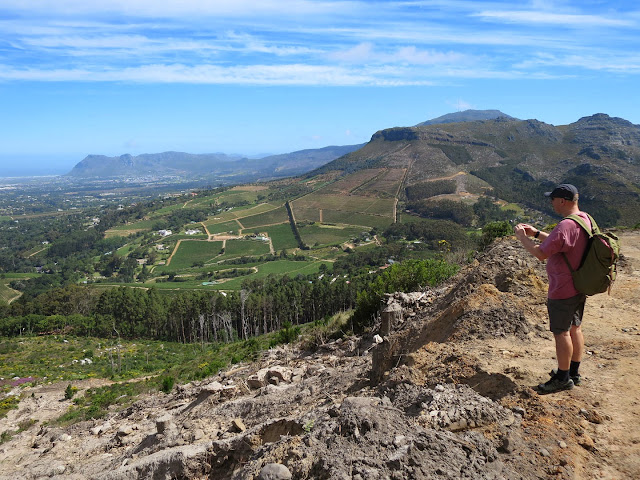
The Frenchman and I went on a three hour walk, first driving for about ten minutes from home and parking at Constantia Neck.
We hiked up past Eagle's Nest and then straight up some rocky scrambles towards the top of the mountain and the sculpted sandstone rocks, the most famous of which looks kinda-sorta like a camel. You'll have to wait for the Frenchman's post to see the camel.
We stopped a lot for pictures (and breathers, for me: it's steep - he could just trot the whole thing), but if you were just charging from one end to the other, I think this walk could be done in two hours. The views are spectacular.
Busted on the ascent! Checking a mobile device while in nature: Tsk. But the Frenchie likes to records his routes by GPS, and was presumably checking to see whether his satellite was awake and tracking him.
Aristea macrocarpa
Berkheya armata
Homo francophoniens
The view over the Hout Bay Valley.
Ascending...
Ixia polystachya
At last, the top!
Leucadendron sp.
Struthiola sp.
(Vince hiking with his small camera on his hip. The backpack with full kit is superheavy, and too valuable.)
Halfway, or more, and downhill from here. My father's mom was a De Villiers...no other connection.
Psoralea sp.
Bad photo with zoom, but my parents' house.
We stopped here for lunch, on the jeeptrack that allows infrequent vehicles to access the ranger's station on top, one of very few structures on the mountain.
Carniverous Drosera trinervia on the cool rock faces beside the road. Accompanied by a soundtrack of click frogs
Watsonia coccinea
Scabiosa africana, and unsure about the yellow. Cotula?
Formerly Albuca, now Ornithogalum, poss. imbricata. Like green snowdrops.
The way home, back to Constantia Neck. After our move from Brooklyn to Harlem, and starting originally during a garden installation he helped out on some years ago (outsize bags of soil up stairs), Vince's knees have been a bit funny. So he was worried about this long downhill jolt. But they were fine.
Massive early summer and unseasonal rain caused unprecedented mudslides on the mountain.
Moraea tricuspidata
And then we were down again.
A short drive, and cold gin and tonics waited for us in my mother's garden.
And now for the lecture.
Table Mountain Hiking Essentials and Tips:
1. Hike with companions.
2. The weather on this mountain turns on a dime. Pack an extra layer as well as a windproof jacket, no matter how hot it is down below. Trust me.
3. Contrary to popular belief, Table Mountain is not flat. Wear walking shoes or boots. Remember
flipflop girl?
4. Pack water and snacks.
5. The sun in South Africa will fry you silly. Ozone hole. Sunscreen, and hat, if you do hats.
6. Map.
Slingsby's hiking maps cover the whole mountain.
7. Inform someone of your route, and your approximate return time. Stick to that route.
8. Allow the least fit or slowest member of the party to walk in front. They should set the pace (er, that would be me).
9. Personal Safety:
i) Leave jewelry at home. We remove our wedding rings.
ii) Pack as few expensive toys as possible, and keep them in a backpack, not swinging from your neck. A camera is my necessity. I prefer a point-and-shoot on hikes as it's light and held in my hand or a pocket, and not ostentatious. Cellphone is useful if you get lost or need help.
iii) In the unlikely event that you do encounter unfriendlies, cooperate. Be meek and unconfrontational, and as calm as possible.
Hand over everything. Your goal is to leave the situation unharmed, not save a camera. Take nothing on your hike you are not prepared to lose.
iv) For a highly unlikely, worst-case scenario, I take pepper spray. Keep it in a pocket. It's no use to you out of reach in a backpack. Should you have to use it, bear in mind that with the frequent wind you are likely to be sprayed by your own spray. Be aware of wind direction and stay upwind of spray. Practise at home. Personally, I think a codeword is useful if you are in group. At the word, everyone drops, turns and covers eyes and nose. I know. Very dramatic. It's unlikely to happen, but be prepared.
I have never had a bad experience on the mountain. Thousands of people hike this mountain on a regular basis, safely. But headlines are headlines. Most injuries and all (as far as I know) not-infrequent fatalities on this apparently friendly mountain are caused by user-error. Falls, dehydration, lack of preparation and unfitness, and plain stupidity.
But there have been and continue to be muggings, and a minority are violent. Areas to avoid: Karbonkelberg above Hout Bay, Sandy Bay dunes, caution on lower slopes of Lion's Head.
But that leaves you an awful lot of mountain, from Cape Point to Maclear's Beacon.
Hike forth!


